Rosa’s Rains Begin: North Phoenix Faces Flash Flooding
UPDATED 9:40 p.m. Sunday — The remains of Hurricane Rosa reached Arizona Sunday and are expected to bring 2 to 3 inches of rain to North Phoenix. Flash Flood Watches are in effect for Phoenix and other parts of the state, with Anthem, New River and other areas north of the Carefree Highway most at risk for heavy rains and flash floods as mountains enhance rainfall potential. Showers will most arrived in North Phoenix by late evening. And then the rain will persist.
Editor’s Note: A newer article on the storm has been published. See our Weather News page for the latest.
Rosa is now a tropical storm, as top sustained winds around 65 mph Sunday night—after reaching as high as 145 mph Thursday, according to the National Hurricane Center. The weakening was expected. But the system still carries ample moisture, much of which will be dumped on Arizona. [See: Hurricanes That Have Affected Phoenix]
“It’s really all about the rain,” said Austin Jamison, a meteorologist at the National Weather Service office in Phoenix. If the expected track holds, flash flooding is likely in Phoenix, and “especially in North Phoenix, and especially north of the Carefree Highway,” Jamison said.
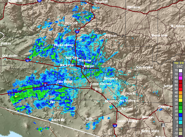
The latest radar image (above) show significant rain already in some parts of Arizona. There have been reports flooding near Yuma. Small amounts of rain have fallen near Yarnell to the northwest. Gila Bend, southwest of Phoenix, has received a third of an inch.
This is just the first of about three phases of this storm.
What to Expect
On a somewhat rare note, the chance of rain Monday night has now been put at 100 percent by the NWS:
The rain arrived even as Rosa’s center was about 200 miles offshore at 8 p.m. Sunday. The storm center won’t cross into Arizona until Tuesday morning—by then reduced to a tropical depression—and it’ll be sometime Wednesday before the center exits the state’s northern border.
There remains little uncertainty in the rainfall forecast now.
If the storm tracks as expected, North Phoenix will likely get 2 to 3 inches. But if it veers east or west, the total could drop to an inch or less, Jamison told North Phoenix News Sunday morning. But that scenario became less likely by Sunday night, as confidence in the storm’s path grew.
There’s little chance of Phoenix seeing 4 inches or more, he said.
The heaviest rain could fall in New River, and parts north, in the mountains of Yavapai County, Jamison said. [Sandbag Pickup Locations]
Accurate So Far
Worth noting: The National Hurricane Center forecasts on Rosa, going clear back to Friday morning, predicted almost exactly played out Sunday. “Things are progressing largely as forecast,” Jamison said. “There have not really been a whole lot of surprises in terms of intensity and track.”
The National Hurricane Center has called for isolated pockets of up to 6 inches of rain along the Mogollon Rim. Unlike typical monsoon storms, which can be violent, wind won’t be much of a factor in this storm, with gusts up to 25 mph predicted for Monday.
Flash Flood Risk
Arizona has plenty of experience dealing with the effects of hurricane remnants. The biggest threat is typically flooding, and especially flooding coupled with bravery or stupidity.
Jamison cautioned drivers to be extra careful. The Flash Flood Watch means there is a better than 50 percent chance that a Flash Flood Warning will be issued for the region.
“Monday night into Tuesday, that’s the main window where we’ll see very persistent and frequent showers, and occasionally heavy rain,” he said. “That’s the time frame when flash flooding is most likely.”
Particularly in North Phoenix up into mountainous areas, “normally dry washes will be running,” he said, and some crossings may be impassible. “It can be really difficult to tell how deep it is,” Jamison said. “Especially at night. That’s danger time.”
“Turn around, don’t drown” is the agency’s mantra.