Seriously? Phoenix Forecasters Now Watching Hurricane Sergio
UPDATE TUESDAY, OCT. 9 — The latest forecast shows Sergio’s center likely tracking south of Arizona, in Mexico. It is still expected to interact with moisture in Arizona, which could bring rain to the Valley Thursday into Friday. But Sergio itself is unlikely to drench Phoenix, forecasters day. The article below remains as originally written and updated.
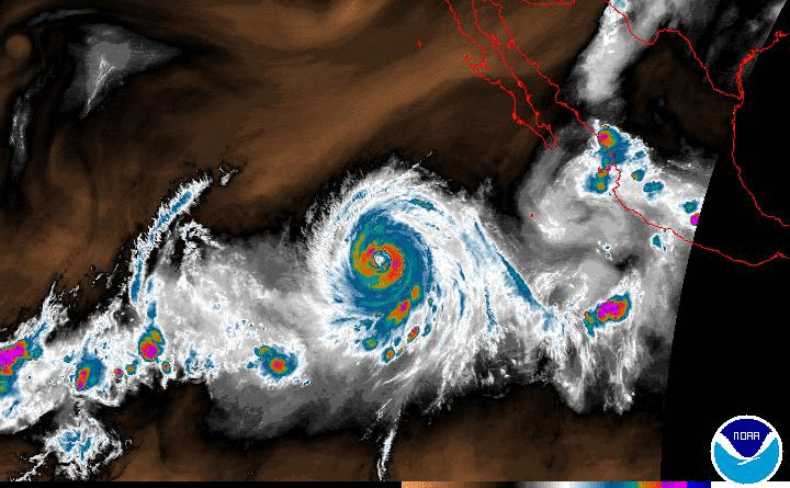
UPDATED 8:56 a.m. Saturday, Oct 6 — Yes, yes, it sounds crazy. And let’s be clear: It’s too soon to say if Hurricane Sergio’s remnants will drench Arizona. But just days after the remains of Hurricane Rosa blew through, dumping up to 3 inches in North Phoenix, the National Weather Service is eyeing another Pacific hurricane that could … could … ultimately bring more moisture our way.
“Since it is nearly a week away, there is still a decent amount of uncertainty in the track,” the National Weather Service’s Phoenix office said Friday morning, but the bulk of the hurricane forecasting models “show the track through southeast Arizona.”
Before that happens, we’re in for some rain this weekend due to an unrelated cold front that is forming off the Pacific Northwest coast and will “dive south-southeast,” the NWS says.
“The forecast over the next week or so is quite interesting, as we have an unseasonably strong and cold Pacific system move in late in the weekend and then possibly another tropical system (Sergio) to deal with late next week,” the NWS said.
More on Sergio Below. But First …
This weekend’s forecast calls for a quarter-inch to a half-inch of rain in Phoenix, expected Saturday night into Sunday.
“As the cold front dips southeast during the overnight before stalling out over central Arizona Sunday, we should see showers and thunderstorms develop across La Paz and Maricopa County by sunrise Sunday morning,” according to the NWS forecast.
OK, Now Some Sergio Details …
“Attention then turns to what could be another significant tropical event for portions of the Desert Southwest late next week,” the NWS said in this morning’s long-range analysis.
Sergio is actually moving westward right now, away from Baja. It had top sustained winds of 120 mph earlier today, but is weakening. By early next week it’s expected to curve back to the east and take a track much like Rosa before it, but by Wednesday it’ll still be well out to sea and will likely have fizzled to tropical storm status.
But you know the drill: even as a tropical storm, a system like this packs a ton of moisture that has to fall somewhere. It’s far from clear whether that rain will fall in Phoenix, and no word yet on how much precipitation that might involve.
As of Saturday morning, models show Sergio’s remains could take one of three different possible paths, each of which would have different implications for how much rain Phoenix might get.
“For now, precipitation towards the end of next week looks to be a safe bet but the magnitude and impacts remain to be seen,” the NWS said Saturday morning.
Now Back to This Weekend’s Details …
The full North Phoenix forecast from the National Weather Service:
TODAY: Sunny, with a high near 82. East southeast wind 5 to 10 mph becoming southwest in the afternoon.
TONIGHT: Showers and thunderstorms, mainly after 11pm. Low around 64. Southwest wind 5 to 10 mph. Chance of precipitation is 80%. New rainfall amounts between a quarter and half of an inch possible.
SUNDAY: Showers and thunderstorms likely. Some of the storms could produce heavy rainfall. Mostly cloudy, with a high near 73. Breezy, with a south southwest wind 10 to 15 mph. Chance of precipitation is 70%. New rainfall amounts between a quarter and half of an inch possible.
SUNDAY NIGHT: A 40 percent chance of showers and thunderstorms. Mostly cloudy, with a low around 58. West wind around 5 mph becoming calm.
MONDAY: A 20 percent chance of showers and thunderstorms. Mostly sunny, with a high near 73. East southeast wind around 5 mph becoming southwest in the afternoon.